| |
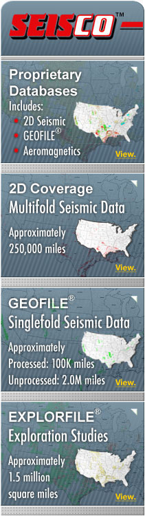
Proprietary Databases
 2D Seismic Data 2D Seismic Data
SEISCO has acquired ownership rights to an extensive library of 2D seismic data from such major and independent oil and gas companies as Arco, Ashland, Bow Valley, British-American, Chevron, Cities, Eastern States, Ensearch, Equitable, ExxonMobil, Forest, Getty, Great Western, Gulf, Harbert, Jones-Van Operating, Kewanee, Occidental, Peco, Placid, Plumb, Reserve, Shubuta, Sinclair, Skelly, Statex, Strago, Tenneco, Texaco, Whitestone and Wiser.
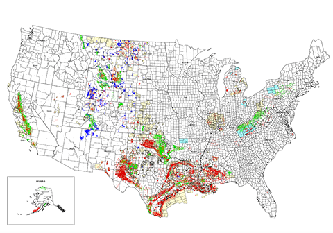
The database consists of approximately 250,000 miles of 2D seismic data located throughout most of the major onshore Sedimentary Basins in the U.S.
Click on SEISCO’s 2D Coverage Map to view coverage.
GEOFILE® Seismic Data
In 1995, SEISCO acquired the assets of GTS Corporation (NASDAQ:GTSC), including its GEOFILE® Database. The original database consisted of approximately 100,000 miles of digitally processed singlefold seismic data.
In addition to the GEOFILE® Database, SEISCO owns approximately 2.0 million miles of additional singlefold seismic data which was originally recorded by most of the major oil and gas companies. The field data can be converted to a digital format and processed into any client-designated display. Upon completion of processing, the reprocessed data becomes part of SEISCO’s GEOFILE® Library Database.
Click on SEISCO’s GEOFILE® Coverage Map to view coverage.
EXPLORFILE® Subsurface Interpretations
The EXPLORFILE® Data is a proprietary database of subsurface geophysical exploration projects comprised of information resulting from the interpretation and/or analysis of certain segments of SEISCOs seismic databases. These geophysical interpretations or exploration studies were developed by major and independent oil and gas companies and are now owned by SEISCO. The studies provide geologists and geophysicists with a unique opportunity to review potential leads and prospects throughout most of the onshore regions of the U.S.
The database consists of more than 10,000 subsurface interpretation projects across the U.S. The EXPLORFILE® Data has also become very useful in evaluating potential CCS and SWD well locations.
Click on SEISCO's EXPLORFILE® Coverage Map to view the initial phase of geographic locations of the scanned exploration studies database.
Aeromagnetic Surveys
SEISCO has acquired ownership rights to approximately 22,000 square miles of aeromagnetic data within the States of Arkansas, Kentucky, New York, Ohio and Pennsylvania. Most of these surveys were flown by Applied Geophysics, Inc. which specializes in mapping basement faults under the sedimentary section. The surveys are useful in laying out 2D seismic surveys and/or selecting the boundaries for 3D seismic surveys. The aeromagnetic data can be supplied in raw, processed or interpreted formats.
Click on SEISCO's Aeromagnetic Map to view coverage.
To request seismic data availability in your area of interest or to request information on any other services, please call SEISCO at
504-731-2995 or contact us by using the Contact Form.
|
|
|
|